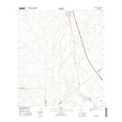
2016 Map of Whitsett
USGS Topo · Published 2016About this map
The Atascosa River carves a central path through this South Texas landscape, marking the transition between the rolling Lipan Hills and the alluvial plains of the Brush Country. Settled along the northern reach, Campbellton serves as a local hub with its grid of streets including Commerce St and San Antonio St, while the community of Whitsett anchors the southeastern corner. This terrain is defined by a network of drainage creeks such as La Parita Cr and Metate Cr, which feed into the river basin.
Find a feature on this map
33 named features on this map. Tap any name to fly to it.
Don’t see what you’re looking for? This feature index may not catch every label — zoom into the map to look around manually.
Map Details
Editions of this 2016 Whitsett Map
This is the sole edition of this map. No revisions or reprints were ever made.
Other maps of this area

1925 · Crowther No. 3
USGS Topo · 1:48,000

1930 · Whitsett
USGS Topo · 1:62,500

1931 · Falls City
USGS Topo · 1:62,500

1942 · Whitsett
USGS Topo · 1:62,500

1953 · Crystal City
USGS Topo · 1:250,000

1955 · Crystal City
USGS Topo · 1:250,000

1956 · Suniland
USGS Topo · 1:62,500

1956 · Pleasanton
USGS Topo · 1:62,500

1961 · Crystal City
USGS Topo · 1:250,000
1961 · Fashing
USGS Topo · 1:24,000