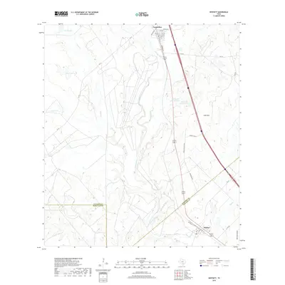
2019 Map of Whitsett
USGS Topo · Published 2019About this map
Campbellton sits at the northern edge of this South Texas landscape, where the Atascosa River winds through a terrain defined by ranching and ephemeral waterways. The map illustrates a transition from the river bottomlands up into the Lipan Hills, showing a network of rural routes such as FM 791 and FM 1099 that connect isolated homesteads and ranching operations. To the south, the community of Whitsett is positioned near the junction of major transit corridors and Olmos Cr, reflecting the region's historical reliance on both the river and modern road networks.
Find a feature on this map
30 named features on this map. Tap any name to fly to it.
Don’t see what you’re looking for? This feature index may not catch every label — zoom into the map to look around manually.
Map Details
Editions of this 2019 Whitsett Map
This is the sole edition of this map. No revisions or reprints were ever made.
Other maps of this area

1925 · Crowther No. 3
USGS Topo · 1:48,000

1930 · Whitsett
USGS Topo · 1:62,500

1931 · Falls City
USGS Topo · 1:62,500

1942 · Whitsett
USGS Topo · 1:62,500

1953 · Crystal City
USGS Topo · 1:250,000

1955 · Crystal City
USGS Topo · 1:250,000

1956 · Suniland
USGS Topo · 1:62,500

1956 · Pleasanton
USGS Topo · 1:62,500

1961 · Crystal City
USGS Topo · 1:250,000
1961 · Fashing
USGS Topo · 1:24,000