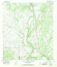
1965 Map of Whitsett
USGS Topo · Published 1968About this map
Campbellton serves as the northern anchor of this landscape, situated where the Missouri Pacific railroad cuts through the brush country of South Texas. The area is defined by the convergence of several major drainages, including the Atascosa River and its tributaries like La Parita Creek and Metate Creek. These waterways carve through the prominent Lipan Hills, creating a terrain of draws and hollows such as Merriman Hollow. The map reveals a rural economy centered on large ranching operations like the 74 Ranch and Tom Ranch, alongside active extractive industry as evidenced by several Gravel Pits scattered near the rail line. To the south, the settlement of Whitsett marks the boundary between Atascosa, McMullen, and Live Oak counties, illustrating how early transportation corridors dictated the placement of these remote outposts.
Find a feature on this map
19 named features on this map. Tap any name to fly to it.
Don’t see what you’re looking for? This feature index may not catch every label — zoom into the map to look around manually.
Map Details
Editions of this 1965 Whitsett Map
2 editions found
Other maps of this area

1925 · Crowther No. 3
USGS Topo · 1:48,000

1930 · Whitsett
USGS Topo · 1:62,500

1931 · Falls City
USGS Topo · 1:62,500

1942 · Whitsett
USGS Topo · 1:62,500

1953 · Crystal City
USGS Topo · 1:250,000

1955 · Crystal City
USGS Topo · 1:250,000

1956 · Suniland
USGS Topo · 1:62,500

1956 · Pleasanton
USGS Topo · 1:62,500

1961 · Crystal City
USGS Topo · 1:250,000
1961 · Fashing
USGS Topo · 1:24,000