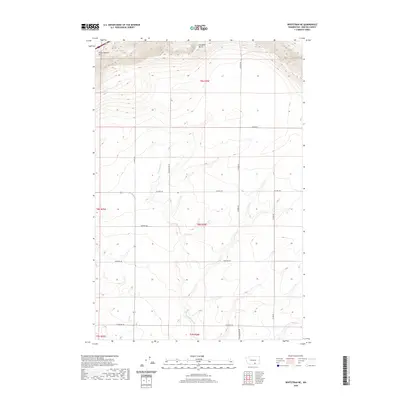
2020 Map of Whitstran NE
USGS Topo · Published 2020About this map
The Horse Heaven Hills rise across the northern section of this Benton County landscape, where Chandler Butte stands as a primary topographical landmark. This 2020 survey captures a region defined by agricultural parcels and a geometric grid of rural access roads. The drainage of E Br Glade Cr cuts through the central terrain, providing a natural break in the organized network of sections. Genealogists and local historians can trace the paths of family-named routes such as Tyacke Rd, Stephen Rd, and Weller Rd, which connect scattered homesteads and farming operations. The presence of Cemetery Rd indicates a site of community significance within this sparse, high-country environment. The map provides a clear look at the township and range boundaries including t8n r26e, reflecting the enduring structure of Washington's land division in the early 21st century.
Find a feature on this map
19 named features on this map. Tap any name to fly to it.
Don’t see what you’re looking for? This feature index may not catch every label — zoom into the map to look around manually.
Map Details
Editions of this 2020 Whitstran NE Map
This is the sole edition of this map. No revisions or reprints were ever made.
Other maps of this area

1915 · Prosser
USGS Topo · 1:125,000

1917 · Pasco
USGS Topo · 1:125,000

1917 · Prosser
USGS Topo · 1:125,000

1951 · Richland
USGS Topo · 1:62,500

1951 · Corral Canyon
USGS Topo · 1:62,500

1953 · Walla Walla
USGS Topo · 1:250,000

1958 · Walla Walla
USGS Topo · 1:250,000

1965 · Whitstran
USGS Topo · 1:62,500
1965 · Prior Ranch
USGS Topo · 1:24,000
1965 · Whitstran SE
USGS Topo · 1:24,000