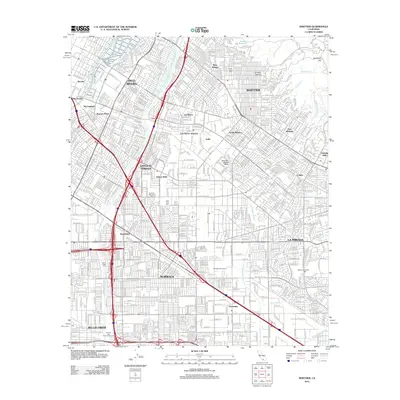
2012 Map of Whittier
USGS Topo · Published 2012About this map
Whittier and the surrounding Los Angeles basin communities are defined by a dense grid of residential streets and industrial corridors at the turn of the 21st century. The San Gabriel River corridor provides a central north-south axis, paralleled by the San Gabriel River Freeway, while the Union Pacific railroad lines trace the industrial history of areas like Los Nietos and Valla. The map reveals the suburban expansion of Norwalk, La Mirada, and Pico Rivera, showing a landscape where major thoroughfares like the Santa Ana Freeway intersect with established neighborhoods. For those researching local history, the placement of several notable cemeteries, including Mount Olive Cem and Paradise Memorial Park, alongside institutional landmarks like Biola University, offers clear points of reference for the mid-to-late 20th-century development of this region. The hills to the northeast, including Workman Hill and Turnbull Canyon, offer a sharp contrast to the flat, urbanized plains below.
Find a feature on this map
45 named features on this map. Tap any name to fly to it.
Don’t see what you’re looking for? This feature index may not catch every label — zoom into the map to look around manually.
Map Details
Editions of this 2012 Whittier Map
This is the sole edition of this map. No revisions or reprints were ever made.
Other maps of this area

1894 · Los Angeles
USGS Topo · 1:62,500

1894 · Pomona
USGS Topo · 1:62,500

1896 · Pasadena
USGS Topo · 1:62,500

1896 · Anaheim
USGS Topo · 1:62,500

1896 · Downey
USGS Topo · 1:62,500

1897 · Pomona
USGS Topo · 1:62,500

1898 · Pomona
USGS Topo · 1:62,500

1898 · Anaheim
USGS Topo · 1:62,500

1899 · Downey
USGS Topo · 1:62,500

1900 · Pasadena
USGS Topo · 1:62,500