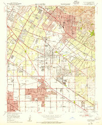
1949 Map of Whittier
USGS Topo · Published 1955About this map
Pico Mansion State Historical Monument and the grounds of Whittier College highlight the developed landscape of eastern Los Angeles County during the late 1940s. This survey records a period of intense post-war expansion where agricultural land grants like Paso de Bartolo and Gertrudes (Colima) were increasingly occupied by burgeoning suburbs and industrial infrastructure. The region's heavy reliance on petroleum is evident in the dense network of oil refineries and sumps surrounding Santa Fe Springs and South Whittier.
Find a feature on this map
101 named features on this map. Tap any name to fly to it.
Don’t see what you’re looking for? This feature index may not catch every label — zoom into the map to look around manually.
Map Details
Editions of this 1949 Whittier Map
This is the sole edition of this map. No revisions or reprints were ever made.
Other maps of this area

1894 · Los Angeles
USGS Topo · 1:62,500

1894 · Pomona
USGS Topo · 1:62,500

1896 · Pasadena
USGS Topo · 1:62,500

1896 · Anaheim
USGS Topo · 1:62,500

1896 · Downey
USGS Topo · 1:62,500

1897 · Pomona
USGS Topo · 1:62,500

1898 · Pomona
USGS Topo · 1:62,500

1898 · Anaheim
USGS Topo · 1:62,500

1899 · Downey
USGS Topo · 1:62,500

1900 · Pasadena
USGS Topo · 1:62,500