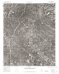
1974 Map of Whittier
USGS Topo · Published 1975About this map
Whittier and the surrounding industrial and residential heart of Southeast Los Angeles are captured in high-altitude detail in this mid-1970s orthophoto. Unlike a traditional topographic map, this photographic survey reveals the actual density of the urban grid, spanning the densely packed neighborhoods of Downey and Pico Rivera. The image illustrates the complex geometry of the regional freeway system as it cuts through the suburban landscape, connecting established centers like Norwalk to the broader Southern California sprawl. This specific vantage point is particularly useful for observing the mid-century transformation of the landscape, where commercial corridors and manufacturing hubs had largely replaced the area's earlier agricultural footprint. Researchers can trace the exact footprint of industrial sites and public infrastructure as they appeared during this period of significant regional growth.
Find a feature on this map
4 named features on this map. Tap any name to fly to it.
Don’t see what you’re looking for? This feature index may not catch every label — zoom into the map to look around manually.
Map Details
Editions of this 1974 Whittier Map
This is the sole edition of this map. No revisions or reprints were ever made.
Other maps of this area

1894 · Los Angeles
USGS Topo · 1:62,500

1894 · Pomona
USGS Topo · 1:62,500

1896 · Pasadena
USGS Topo · 1:62,500

1896 · Anaheim
USGS Topo · 1:62,500

1896 · Downey
USGS Topo · 1:62,500

1897 · Pomona
USGS Topo · 1:62,500

1898 · Pomona
USGS Topo · 1:62,500

1898 · Anaheim
USGS Topo · 1:62,500

1899 · Downey
USGS Topo · 1:62,500

1900 · Pasadena
USGS Topo · 1:62,500