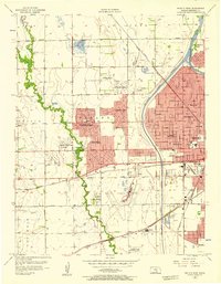
1956 Map of Wichita West
USGS Topo · Published 1957About this map
Wichita expands westward during the mid-1950s, as suburban developments like Westlink Village, Rolling Hills, and Country Acres begin to fill the landscape between the Arkansas River and the meandering Cowskin Creek. This era of growth is defined by the proliferation of planned communities and institutional foundations, such as Sacred Heart College and Mount Carmel Academy. The geography reveals a transition from the agricultural roots of Delano and Attica townships toward a modernized urban fringe, anchored by the Wichita Municipal Airport and a network of new residential estates.
Find a feature on this map
52 named features on this map. Tap any name to fly to it.
Don’t see what you’re looking for? This feature index may not catch every label — zoom into the map to look around manually.
Map Details
Editions of this 1956 Wichita West Map
This is the sole edition of this map. No revisions or reprints were ever made.
Other maps of this area

1889 · Cheney
USGS Topo · 1:125,000

1889 · Wichita
USGS Topo · 1:125,000

1891 · Cheney
USGS Topo · 1:125,000

1894 · Wichita
USGS Topo · 1:125,000

1901 · Cheney
USGS Topo · 1:125,000

1941 · Maize
USGS Topo · 1:31,680

1941 · Valley Center
USGS Topo · 1:31,680

1942 · Valley Center
USGS Topo · 1:31,680

1942 · Maize
USGS Topo · 1:31,680

1943 · Wichita West
USGS Topo · 1:31,680