
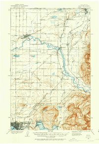
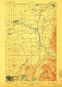
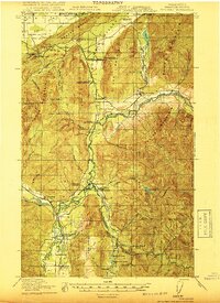
1921 Map of Wickersham
USGS Topo · Published 1944About this map
The Skagit River and the South Fork Nooksack River define this Pacific Northwest landscape during a period of heavy industrial timber and mineral extraction. This 1921 survey reveals a complex network of transportation, where the Great Northern RR and Northern Pacific RR intersect at Sedro Woolley and Cokedale Junction. The extractive economy is evident in the presence of the Cokedale Mine and numerous Logging RR spurs that climb into the surrounding foothills of Blue Mountain and Anderson Mountain.
Find a feature on this map
71 named features on this map. Tap any name to fly to it.
Don’t see what you’re looking for? This feature index may not catch every label — zoom into the map to look around manually.
Map Details
Editions of this 1921 Wickersham Map
2 editions found
Other maps of this area

1899 · Stillaguamish
USGS Topo · 1:125,000

1901 · Stilaguamish
USGS Topo · 1:125,000
1906 · Sumas
USGS Topo · 1:62,500
1908 · Sumas
USGS Topo · 1:62,500

1909 · Mt Baker
USGS Topo · 1:192,000

1911 · Mount Vernon
USGS Topo · 1:125,000

1915 · Mt. Baker
USGS Topo · 1:250,000

1918 · Samish Lake
USGS Topo · 1:62,500
1919 · Van Zandt
USGS Topo · 1:62,500

1921 · Wickersham
USGS Topo · 1:62,500