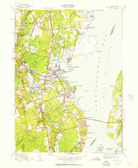
1942 Map of Wickford
USGS Topo · Published 1957About this map
The Annaquatucket River and Mattatuxet River power a landscape defined by textile-era waterworks, as seen in the various impoundments like Hamilton Reservoir and Davisville Mill Pond. This mid-century coastal survey documents the transition between old mill settlements and the burgeoning military and transit infrastructure of North Kingstown. The New York New Haven and Hartford RR bisects the region, connecting Wickford Junction to the broader corridor while the recently completed Jamestown Bridge spans the West Passage to Conanicut Island. Along the shoreline, historical defenses at Fort Greble on Dutch Island stand watch over the harbor, while local history is preserved in the Quidnessett Cem and Allenton Cem. The map reveals a dense network of post-colonial villages such as Lafayette, Hamilton, and Saunderstown, still deeply tied to their river-mouth locations.
Find a feature on this map
102 named features on this map. Tap any name to fly to it.
Don’t see what you’re looking for? This feature index may not catch every label — zoom into the map to look around manually.
Map Details
Editions of this 1942 Wickford Map
This is the sole edition of this map. No revisions or reprints were ever made.
Other maps of this area

1889 · Charlestown
USGS Topo · 1:62,500

1889 · Newport
USGS Topo · 1:62,500

1890 · Narragansett Bay
USGS Topo · 1:62,500

1890 · Kent
USGS Topo · 1:62,500

1892 · Narragansett Bay
USGS Topo · 1:62,500

1894 · Kent
USGS Topo · 1:62,500

1894 · Newport
USGS Topo · 1:62,500

1904 · Newport
USGS Topo · 1:62,500

1919 · Charlestown
USGS Topo · 1:62,500

1919 · Narragansett Bay
USGS Topo · 1:62,500