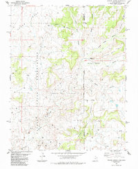
1985 Map of Wickiup Canyon
USGS Topo · Published 1985About this map
Navajo Indian Reservation territory meets the Colorado and Utah state line in this mid-1980s topographical study. The high desert landscape is defined by massive tablelands such as Cajon Mesa and Cannon Ball Mesa, which are deeply incised by drainage systems like Wickiup Canyon and Little Ruin Canyon. This era shows a landscape undergoing intensive resource extraction, characterized by a dense network of exploration infrastructure throughout the Ismay Oil Field.
Find a feature on this map
24 named features on this map. Tap any name to fly to it.
Don’t see what you’re looking for? This feature index may not catch every label — zoom into the map to look around manually.
Map Details
Editions of this 1985 Wickiup Canyon Map
This is the sole edition of this map. No revisions or reprints were ever made.
Other maps of this area

1886 · Abajo
USGS Topo · 1:250,000

1892 · Abajo
USGS Topo · 1:250,000

1893 · Abajo
USGS Topo · 1:250,000

1956 · Cortez
USGS Topo · 1:250,000

1957 · Moqui NW
USGS Topo · 1:24,000

1957 · Aneth 1 NE
USGS Topo · 1:24,000

1957 · Aneth 1 NW
USGS Topo · 1:24,000

1957 · Moqui SW
USGS Topo · 1:24,000

1958 · Sentinel Peak NW
USGS Topo · 1:24,000

1958 · Cortez
USGS Topo · 1:250,000