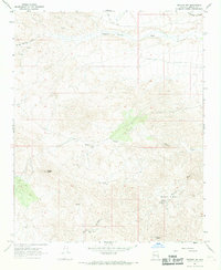
1967 Map of Wikieup NW
USGS Topo · Published 1969About this map
High peaks and isolated water sources define this 1960s desert landscape in Mohave County. Prominent summits like Aubrey Peak and Groom Peak tower over a network of intermittent drainage systems, including the steep-walled Devils Canyon and the winding Natural Corrals Wash. The map records a series of essential improvements in this arid ranching country, from the Beevers Well and Greenwood Well to the specialized Devils Canyon Well and Donegay Well. These scattered points of water represent the lifeline for livestock and human activity across Shannon Basin. Evidence of earlier resource exploration is visible at a single Prospect located near Stove Spring Canyon. The presence of several Corrals and a sparse network of Jeep Trails underscores the seasonal and rugged nature of land use in this territory before the further expansion of regional infrastructure.
Find a feature on this map
23 named features on this map. Tap any name to fly to it.
Don’t see what you’re looking for? This feature index may not catch every label — zoom into the map to look around manually.
Map Details
Editions of this 1967 Wikieup NW Map
This is the sole edition of this map. No revisions or reprints were ever made.
Other maps of this area

1923 · Signal
USGS Topo · 1:250,000

1942 · Signal
USGS Topo · 1:250,000

1950 · Prescott
USGS Topo · 1:250,000

1954 · Prescott
USGS Topo · 1:250,000

1958 · Prescott
USGS Topo · 1:250,000

1959 · Prescott
USGS Topo · 1:250,000

1960 · Prescott
USGS Topo · 1:250,000

1965 · Prescott
USGS Topo · 1:250,000
1967 · Groom Spring
USGS Topo · 1:24,000
1967 · Dutch Flat SE
USGS Topo · 1:24,000