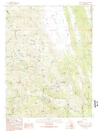
1989 Map of Wilbur Springs
USGS Topo · Published 1989About this map
Wilbur Springs serves as the focal point for this late twentieth-century survey of the high ridge country along the Colusa and Lake county line. The landscape is defined by an intensive history of mineral extraction, with numerous workings such as the Abbott Mine, Turkey Run Mine, and Manzanita Mine clustered near Sulphur Creek. These sites, along with the Wide Awake Mine and Empire Mine, trace a legacy of quicksilver and gold prospecting that shaped the local economy. The terrain transitions from the steep grades of Walker Ridge down to the broad Bear Valley, where Bear Creek and Freshwater Creek drain the eastern slopes. Near the center of the quadrangle, a lonely Schoolhouse stands as a remnant of the small rural community that once supported the surrounding mining and ranching operations in this isolated corner of Northern California.
Find a feature on this map
47 named features on this map. Tap any name to fly to it.
Don’t see what you’re looking for? This feature index may not catch every label — zoom into the map to look around manually.
Map Details
Editions of this 1989 Wilbur Springs Map
This is the sole edition of this map. No revisions or reprints were ever made.
Other maps of this area

1905 · Fairview
USGS Topo · 1:24,000

1920 · Venado
USGS Topo · 1:62,500

1924 · Bartlett Springs
USGS Topo · 1:62,500

1942 · Bartlett Springs
USGS Topo · 1:62,500

1943 · Morgan Valley
USGS Topo · 1:62,500

1944 · Bartlett Springs
USGS Topo · 1:62,500

1944 · Wilbur Springs
USGS Topo · 1:62,500

1944 · Morgan Valley
USGS Topo · 1:62,500

1945 · Lower Lake
USGS Topo · 1:62,500

1947 · Santa Rosa
USGS Topo · 1:250,000