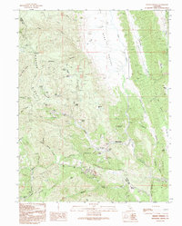
1991 Map of Wilbur Springs
USGS Topo · Published 1995About this map
Wilbur Springs sits at the heart of a high mineral district where Colusa and Lake counties meet, dominated by a legacy of quicksilver and mercury mining. This 1991 survey details an extensive network of extractive sites concentrated along Sulphur Creek and the surrounding heights, including the Abbott Mine, Turkey Run Mine, and the Wide Awake Mine. The landscape is defined by the steep North Coast Range topography of Walker Ridge and Blue Ridge, where rugged four-wheel-drive tracks serve remote outposts like Deadshot and Benmore. Traces of earlier communal life remain visible through features such as the isolated Schoolhouse near Remington Canyon, while the numerous Prospects and Mine Dump labels scattered across the terrain provide a clear record of the area's intensive industrial history.
Find a feature on this map
56 named features on this map. Tap any name to fly to it.
Don’t see what you’re looking for? This feature index may not catch every label — zoom into the map to look around manually.
Map Details
Editions of this 1991 Wilbur Springs Map
This is the sole edition of this map. No revisions or reprints were ever made.
Other maps of this area

1905 · Fairview
USGS Topo · 1:24,000

1920 · Venado
USGS Topo · 1:62,500

1924 · Bartlett Springs
USGS Topo · 1:62,500

1942 · Bartlett Springs
USGS Topo · 1:62,500

1943 · Morgan Valley
USGS Topo · 1:62,500

1944 · Bartlett Springs
USGS Topo · 1:62,500

1944 · Wilbur Springs
USGS Topo · 1:62,500

1944 · Morgan Valley
USGS Topo · 1:62,500

1945 · Lower Lake
USGS Topo · 1:62,500

1947 · Santa Rosa
USGS Topo · 1:250,000