
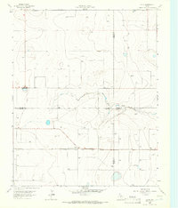
1965 Map of Wilco
USGS Topo · Published 1966About this map
The borderlands of the Texas Panhandle are defined here by a sparse ranching and industrial landscape, split by the Dallam Co Hartley Co line. In the mid-1960s, the region was characterized by the sprawling operations of the Chicago Rock Island and Pacific railroad, which cuts through the southern portion of the sheet. Evidence of local social life appears at the Coloney Community House in the north and the Coldwater Community House near the southern boundary, serving as rare communal landmarks in a territory largely dedicated to resource extraction. The terrain is marked by numerous wells and specialized activity at an Oil Well and a Gravel Pit, while a large Pipeline indicates the movement of energy across this high plains environment.
Find a feature on this map
10 named features on this map. Tap any name to fly to it.
Don’t see what you’re looking for? This feature index may not catch every label — zoom into the map to look around manually.
Map Details
Editions of this 1965 Wilco Map
This is the sole edition of this map. No revisions or reprints were ever made.
Other maps of this area

1954 · Tucumcari
USGS Topo · 1:250,000

1954 · Dalhart
USGS Topo · 1:250,000

1958 · Tucumcari
USGS Topo · 1:250,000

1958 · Dalhart
USGS Topo · 1:250,000

1962 · Dalhart
USGS Topo · 1:250,000

1963 · Hartley NE
USGS Topo · 1:24,000

1963 · Moran Ranch
USGS Topo · 1:24,000

1965 · Conlen
USGS Topo · 1:24,000

1965 · Wilco NE
USGS Topo · 1:24,000
1965 · Exum
USGS Topo · 1:24,000