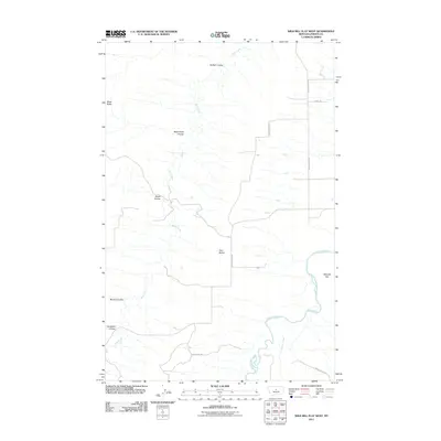
2011 Map of Wild Bill Flat West
USGS Topo · Published 2011About this map
The Judith River winds through this central Montana landscape, defining the southeastern corner of the quadrangle where it meets the drainage of Willow Creek. The topography is a complex network of coulees—dry creek beds that have carved distinct paths through the high plains—including Buffalo Coulee and Blood Coulee. These drainage patterns, feeding into the larger Wolf Creek system, illustrate the natural erosion of the Missouri River watershed in Fergus County. Dominating the central horizon are the Twin Buttes, providing a clear visual landmark for navigation across the open terrain. Human presence is marked by a sparse but essential road network, including Bear Springs Rd and Upper Bench Rd, which follow the higher ground between the coulees and connect the grazing lands of Wild Bill Flat to the broader region.
Find a feature on this map
16 named features on this map. Tap any name to fly to it.
Don’t see what you’re looking for? This feature index may not catch every label — zoom into the map to look around manually.
Map Details
Editions of this 2011 Wild Bill Flat West Map
This is the sole edition of this map. No revisions or reprints were ever made.
Other maps of this area

1954 · Lewistown
USGS Topo · 1:250,000

1959 · Lewistown
USGS Topo · 1:250,000

1964 · Wolf Creek Falls
USGS Topo · 1:24,000

1964 · Anderson Bridge
USGS Topo · 1:24,000

1964 · Spring Coulee
USGS Topo · 1:24,000
1978 · Soda Spring Coulee
USGS Topo · 1:24,000

1978 · Wild Bill Flat West
USGS Topo · 1:24,000

1978 · Toney Bench
USGS Topo · 1:24,000
1978 · Hoosac
USGS Topo · 1:24,000

1978 · Seventytwo Hills
USGS Topo · 1:24,000