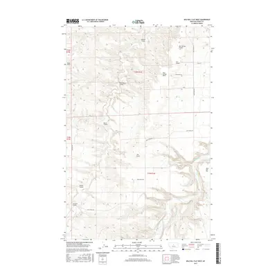
2017 Map of Wild Bill Flat West
USGS Topo · Published 2017About this map
Twin Buttes and the elevation of Black Butte rise above a landscape defined by deep drainage patterns and plateaus in this Fergus County survey. The Judith River flows along the eastern edge of the quadrangle, joined by Willow Creek and fed by numerous topographic depressions including Buffalo Coulee and Mossey Coulee. This terrain is characterized by broad, flat-topped features like Bear Springs Bench and the namesake Wild Bill Flat, which suggest a high-plains environment where water and wind have carved significant relief into the local geography. A few primary thoroughfares, such as Bear Springs Road and Sunnyside Road, navigate the varied elevations, connecting the scattered springs and coulees that mark this section of the Montana interior.
Find a feature on this map
23 named features on this map. Tap any name to fly to it.
Don’t see what you’re looking for? This feature index may not catch every label — zoom into the map to look around manually.
Map Details
Editions of this 2017 Wild Bill Flat West Map
This is the sole edition of this map. No revisions or reprints were ever made.
Other maps of this area

1954 · Lewistown
USGS Topo · 1:250,000

1959 · Lewistown
USGS Topo · 1:250,000

1964 · Wolf Creek Falls
USGS Topo · 1:24,000

1964 · Anderson Bridge
USGS Topo · 1:24,000

1964 · Spring Coulee
USGS Topo · 1:24,000
1978 · Soda Spring Coulee
USGS Topo · 1:24,000

1978 · Wild Bill Flat West
USGS Topo · 1:24,000

1978 · Toney Bench
USGS Topo · 1:24,000
1978 · Hoosac
USGS Topo · 1:24,000

1978 · Seventytwo Hills
USGS Topo · 1:24,000