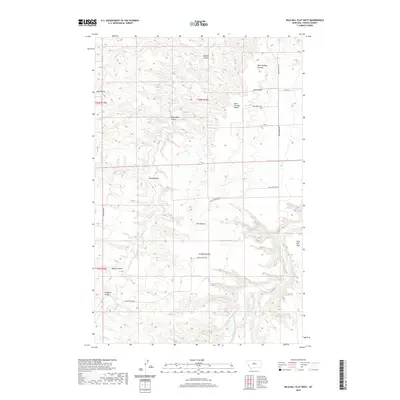
2020 Map of Wild Bill Flat West
USGS Topo · Published 2020About this map
The Judith River cuts through the southeastern corner of this Fergus County landscape, marking a significant drainage point for the surrounding high plains. The terrain is defined by a dense network of coulees, including Buffalo Coulee, Blood Coulee, and Mossey Coulee, which channel seasonal runoff toward Wolf Cr and other tributaries. These features underscore the highly dissected nature of the area, where the flat upland surfaces of Wild Bill Flat and Bear Springs Bench are broken by steep-sided draws. Prominent landmarks such as Black Butte and the Twin Buttes provide vertical relief in an area primarily used for grazing and rangeland. The presence of Bear Springs Rd and Sunnyside Rd indicates the established rural access network that connects these remote parcels, while the unnamed 19N16E10DDD_01 Spring highlights the vital importance of localized water sources in this arid Montana environment.
Find a feature on this map
23 named features on this map. Tap any name to fly to it.
Don’t see what you’re looking for? This feature index may not catch every label — zoom into the map to look around manually.
Map Details
Editions of this 2020 Wild Bill Flat West Map
This is the sole edition of this map. No revisions or reprints were ever made.
Other maps of this area

1954 · Lewistown
USGS Topo · 1:250,000

1959 · Lewistown
USGS Topo · 1:250,000

1964 · Wolf Creek Falls
USGS Topo · 1:24,000

1964 · Anderson Bridge
USGS Topo · 1:24,000

1964 · Spring Coulee
USGS Topo · 1:24,000
1978 · Soda Spring Coulee
USGS Topo · 1:24,000

1978 · Wild Bill Flat West
USGS Topo · 1:24,000

1978 · Toney Bench
USGS Topo · 1:24,000
1978 · Hoosac
USGS Topo · 1:24,000

1978 · Seventytwo Hills
USGS Topo · 1:24,000