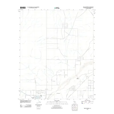
2012 Map of Wild Crossing
USGS Topo · Published 2012About this map
Silver Lakes and the surrounding high desert terrain define this study of San Bernardino County during the early 21st century. The Mojave River serves as the primary geographic corridor, carving a path through the landscape near the landmark Point of Rocks and the namesake Wild Crossing. Settlement patterns here reflect a mix of established desert ranching and newer residential development, with the curvilinear streets of the Silver Lakes community—including Bluegrass Dr and Greenbriar Dr—contrasting sharply against the rigid grid of rural roads like Helendale Rd. To the west, the arid topography is shaped by Buckthorn Canyon and Buckthorn Wash, while historical transport routes are referenced through labels like the Santa Fe Trl and Mojave Trl, highlighting the area's long-standing role as a passage through the Mojave Desert.
Find a feature on this map
59 named features on this map. Tap any name to fly to it.
Don’t see what you’re looking for? This feature index may not catch every label — zoom into the map to look around manually.
Map Details
Editions of this 2012 Wild Crossing Map
This is the sole edition of this map. No revisions or reprints were ever made.
Other maps of this area

1932 · Barstow
USGS Topo · 1:125,000

1934 · Barstow
USGS Topo · 1:125,000

1953 · San Bernardino
USGS Topo · 1:250,000

1956 · San Bernardino
USGS Topo · 1:250,000

1956 · Hawes
USGS Topo · 1:62,500
1956 · Victorville NW
USGS Topo · 1:24,000

1956 · Barstow
USGS Topo · 1:62,500

1956 · Helendale
USGS Topo · 1:24,000
1956 · Victorville
USGS Topo · 1:62,500

1957 · Apple Valley
USGS Topo · 1:62,500