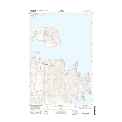
2014 Map of Wild Horse Island
USGS Topo · Published 2014About this map
Wild Horse Island dominates the northern waters of Flathead Lake in this 2014 survey, a massive landmass defined by its steep interior topography and proximity to the smaller Melita Island. On the southern mainland, the settlement of Lindisfarne sits along the irregular shoreline, characterized by numerous inlets and points. The map reveals a transition from the structured residential roads of Big Arm along Us-93 to the private lanes and landings of the eastern peninsulas.
Find a feature on this map
68 named features on this map. Tap any name to fly to it.
Don’t see what you’re looking for? This feature index may not catch every label — zoom into the map to look around manually.
Map Details
Editions of this 2014 Wild Horse Island Map
This is the sole edition of this map. No revisions or reprints were ever made.
Other maps of this area

1920 · Flathead Lake
USGS Topo · 1:125,000

1956 · Wallace
USGS Topo · 1:250,000

1960 · Wallace
USGS Topo · 1:250,000

1964 · Bull Island
USGS Topo · 1:24,000

1964 · Buffalo Bridge
USGS Topo · 1:24,000

1964 · Wild Horse Island
USGS Topo · 1:24,000

1964 · East Bay
USGS Topo · 1:24,000
1964 · Rollins
USGS Topo · 1:24,000

1964 · Elmo
USGS Topo · 1:24,000

1964 · Polson
USGS Topo · 1:24,000