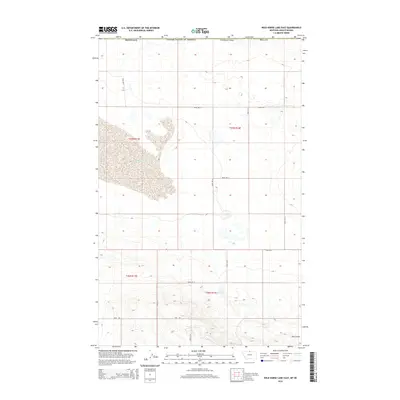
2014 Map of Wild Horse Lake East
USGS Topo · Published 2014About this map
Wildhorse Lake dominates the upper-western landscape of this Hill County borderland, where the high plains of Montana meet the international boundary with Canada. This survey illustrates a vast, sparsely populated agricultural and grazing region defined by its drainage patterns and township grids. Deep incisions like Creedman Coulee in the north and Dog Coulee in the southeast break the undulating terrain, indicating the seasonal flow of water toward the Milk River basin. The map shows a strictly geometric network of gravel and dirt routes, including Base Rd and various numbered section line roads like Road 385 N, which provide access to remote ranching operations. The presence of the UN Reservoir reflects the critical importance of water management in this arid northern environment during the early 21st century.
Find a feature on this map
19 named features on this map. Tap any name to fly to it.
Don’t see what you’re looking for? This feature index may not catch every label — zoom into the map to look around manually.
Map Details
Editions of this 2014 Wild Horse Lake East Map
This is the sole edition of this map. No revisions or reprints were ever made.
Other maps of this area

1912 · Thibedeau Lake
USGS Topo · 1:125,000

1920 · Gildford
USGS Topo · 1:125,000

1943 · Gildford
USGS Topo · 1:125,000

1953 · Havre
USGS Topo · 1:250,000

1954 · Shelby
USGS Topo · 1:250,000

1957 · Havre
USGS Topo · 1:250,000

1958 · Shelby
USGS Topo · 1:250,000

1958 · Havre
USGS Topo · 1:250,000

1972 · Hilldale Colony
USGS Topo · 1:24,000
1972 · Wild Horse Lake West
USGS Topo · 1:24,000