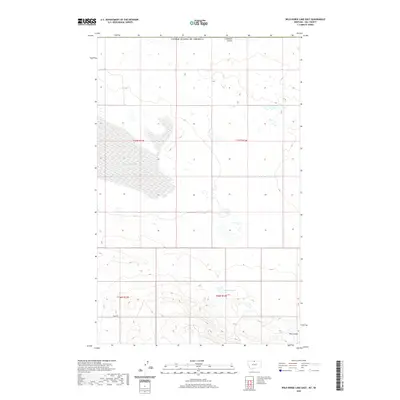
2020 Map of Wild Horse Lake East
USGS Topo · Published 2020About this map
Wild Horse Lake dominates the central landscape of this northern Montana region, its fluctuating shoreline and surrounding wetlands characteristic of the northern high plains. Bordering the international boundary with the United States of America, the area is defined by its drainage patterns and water management infrastructure, including Creedman Coulee to the north and the U N Reservoir further south. The terrain is marked by intermittent water bodies and the deep incisions of Dog Coulee in the southeast. While infrastructure is sparse, Base Rd provides a primary east-west corridor through the township and range divisions. The map reveals the relationship between the natural hydrology of the Great Plains and the systematic land grid used for agricultural and grazing parcels along the Canadian border.
Find a feature on this map
10 named features on this map. Tap any name to fly to it.
Don’t see what you’re looking for? This feature index may not catch every label — zoom into the map to look around manually.
Map Details
Editions of this 2020 Wild Horse Lake East Map
This is the sole edition of this map. No revisions or reprints were ever made.
Other maps of this area

1912 · Thibedeau Lake
USGS Topo · 1:125,000

1920 · Gildford
USGS Topo · 1:125,000

1943 · Gildford
USGS Topo · 1:125,000

1953 · Havre
USGS Topo · 1:250,000

1954 · Shelby
USGS Topo · 1:250,000

1957 · Havre
USGS Topo · 1:250,000

1958 · Shelby
USGS Topo · 1:250,000

1958 · Havre
USGS Topo · 1:250,000

1972 · Hilldale Colony
USGS Topo · 1:24,000
1972 · Wild Horse Lake West
USGS Topo · 1:24,000