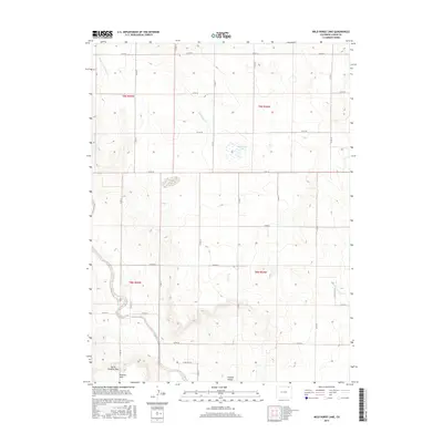
2016 Map of Wild Horse Lake
USGS Topo · Published 2016About this map
Wild Horse Lake sits at the center of this Logan County landscape, surrounded by the high plains of northeastern Colorado. The area is defined by the high ground of the Pawnee Hills and the significant geological break at North Pawnee Pass, which overlooks the broad Pawnee Valley to the south. This 2016 survey illustrates a sparse, modern agricultural grid where the landscape is organized by section lines and county roads, such as Co RD 44 and Co RD 30. Water management is a primary feature of the local geography, visible in the engineered drainage of Pawnee Inlet Number 1 and Pawnee Inlet Number 2, which direct flow through this arid environment. The seasonal nature of the local hydrology is reflected in the ephemeral courses of Wild Horse Cr and Vignette Creek, showing how the land has been adapted for ranching and farming on the plains.
Find a feature on this map
24 named features on this map. Tap any name to fly to it.
Don’t see what you’re looking for? This feature index may not catch every label — zoom into the map to look around manually.
Map Details
Editions of this 2016 Wild Horse Lake Map
This is the sole edition of this map. No revisions or reprints were ever made.
Other maps of this area

1951 · Willard
USGS Topo · 1:24,000

1951 · Wild Horse Lake
USGS Topo · 1:24,000

1951 · Atwood NE
USGS Topo · 1:24,000

1951 · Atwood
USGS Topo · 1:24,000

1954 · Sterling
USGS Topo · 1:250,000

1958 · Sterling
USGS Topo · 1:250,000

1977 · Stoneham NE
USGS Topo · 1:24,000

1977 · Avalo SE
USGS Topo · 1:24,000
1978 · North Sterling Reservoir
USGS Topo · 1:24,000
1978 · Stoneham SE
USGS Topo · 1:24,000