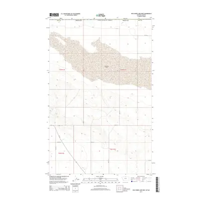
2014 Map of Wild Horse Lake West
USGS Topo · Published 2014About this map
Wild Horse Lake dominates the upper half of this high plains landscape along the United States and Canada border in Hill County. The terrain is defined by the vast, stippled bed of the lake and a series of geometric sections typical of the Public Land Survey System, including t37n r12e and t36n r13e. The area is sparsely populated, with a functional network of gravel and improved roads providing the primary structure for the ranching or farming operations in this borderland. Notable thoroughfares include Mt-232, which runs north-south toward the international boundary, and Hi Grade Rd. This 2014 survey captures a moment of modern land management in Montana, showing a landscape that remains largely open and rural, centered on the drainage patterns and historical township divisions that have dictated local land use for generations.
Find a feature on this map
15 named features on this map. Tap any name to fly to it.
Don’t see what you’re looking for? This feature index may not catch every label — zoom into the map to look around manually.
Map Details
Editions of this 2014 Wild Horse Lake West Map
This is the sole edition of this map. No revisions or reprints were ever made.
Other maps of this area

1912 · Thibedeau Lake
USGS Topo · 1:125,000

1920 · Gildford
USGS Topo · 1:125,000

1943 · Gildford
USGS Topo · 1:125,000

1953 · Havre
USGS Topo · 1:250,000

1954 · Shelby
USGS Topo · 1:250,000

1957 · Havre
USGS Topo · 1:250,000

1958 · Shelby
USGS Topo · 1:250,000

1958 · Havre
USGS Topo · 1:250,000
1972 · Wild Horse Lake West
USGS Topo · 1:24,000
1972 · Cottonwood
USGS Topo · 1:24,000