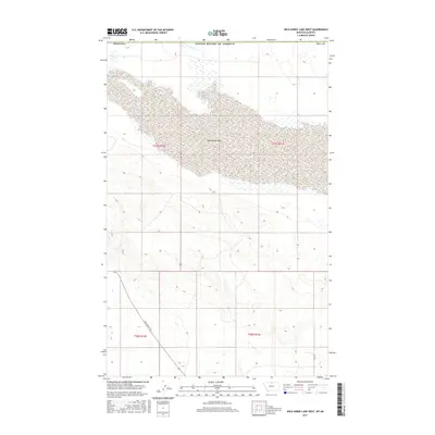
2017 Map of Wild Horse Lake West
USGS Topo · Published 2017About this map
Wild Horse Lake dominates this northern frontier landscape in Hill County, Montana, stretching across the international boundary with Canada. The lake bed is characterized by ephemeral water patterns and expansive wetlands typical of the high plains, where the Montana border meets the Alberta line. This late-stage survey reflects the contemporary geographic layout of the region, emphasizing the sparse but critical transportation network that serves the ranching and agricultural lands south of the border.
Find a feature on this map
9 named features on this map. Tap any name to fly to it.
Don’t see what you’re looking for? This feature index may not catch every label — zoom into the map to look around manually.
Map Details
Editions of this 2017 Wild Horse Lake West Map
This is the sole edition of this map. No revisions or reprints were ever made.
Other maps of this area

1912 · Thibedeau Lake
USGS Topo · 1:125,000

1920 · Gildford
USGS Topo · 1:125,000

1943 · Gildford
USGS Topo · 1:125,000

1953 · Havre
USGS Topo · 1:250,000

1954 · Shelby
USGS Topo · 1:250,000

1957 · Havre
USGS Topo · 1:250,000

1958 · Shelby
USGS Topo · 1:250,000

1958 · Havre
USGS Topo · 1:250,000
1972 · Wild Horse Lake West
USGS Topo · 1:24,000
1972 · Cottonwood
USGS Topo · 1:24,000