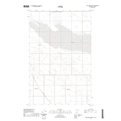
2020 Map of Wild Horse Lake West
USGS Topo · Published 2020About this map
The United States of America border defines the northern edge of this high plains landscape in Hill County, where the topography is shaped by a complex system of seasonal wetlands and drainage patterns. The most prominent human feature is the Wild Horse Trl, which cuts diagonally across the southern sections of the terrain, providing a modern trace of historical movement through this prairie region. To the east, the straight line of Base Rd marks the transition between local township divisions, including t36n r13e and t37n r13e. The map illustrates a largely open area characterized by subtle elevation changes and numerous small water bodies, offering a detailed look at the land survey system and rural infrastructure at the edge of the international boundary.
Find a feature on this map
7 named features on this map. Tap any name to fly to it.
Don’t see what you’re looking for? This feature index may not catch every label — zoom into the map to look around manually.
Map Details
Editions of this 2020 Wild Horse Lake West Map
This is the sole edition of this map. No revisions or reprints were ever made.
Other maps of this area

1912 · Thibedeau Lake
USGS Topo · 1:125,000

1920 · Gildford
USGS Topo · 1:125,000

1943 · Gildford
USGS Topo · 1:125,000

1953 · Havre
USGS Topo · 1:250,000

1954 · Shelby
USGS Topo · 1:250,000

1957 · Havre
USGS Topo · 1:250,000

1958 · Shelby
USGS Topo · 1:250,000

1958 · Havre
USGS Topo · 1:250,000
1972 · Wild Horse Lake West
USGS Topo · 1:24,000
1972 · Cottonwood
USGS Topo · 1:24,000