
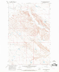
1965 Map of Wild Horse Reservoir
USGS Topo · Published 1969About this map
Wild Horse Reservoir anchors the southern portion of this northern Montana landscape, situated at the confluence of several seasonal drainage systems. The terrain is defined by a network of coulees, including Tin Roof Coulee, Tressler Coulee, and Threemile Coulee, which channel intermittent water toward Wild Horse Creek. This 1965 survey, part of the Missouri River Basin development program, shows a sparsely populated ranching environment where Shaver Ranch stands as a primary landmark in the north. The map documents the intricate topography of the high plains, where numerous small depressions and basins collect water across the flats between West Alkali Creek and Fourmile Coulee. The presence of established ranch names and named watercourses like Spring Coulee and Black Coulee provides essential data for understanding the historical land use and water management of this portion of Phillips County.
Find a feature on this map
13 named features on this map. Tap any name to fly to it.
Don’t see what you’re looking for? This feature index may not catch every label — zoom into the map to look around manually.
Map Details
Editions of this 1965 Wild Horse Reservoir Map
This is the sole edition of this map. No revisions or reprints were ever made.
Other maps of this area

1953 · Havre
USGS Topo · 1:250,000

1957 · Havre
USGS Topo · 1:250,000

1958 · Havre
USGS Topo · 1:250,000

1964 · Coburg SE
USGS Topo · 1:24,000

1964 · Cow Creek
USGS Topo · 1:24,000

1965 · Wagner
USGS Topo · 1:24,000

1965 · West Alkali Reservoir
USGS Topo · 1:24,000

1965 · Phillips
USGS Topo · 1:24,000
1965 · Seymour Reservoir
USGS Topo · 1:24,000

1971 · Big Flat East
USGS Topo · 1:24,000