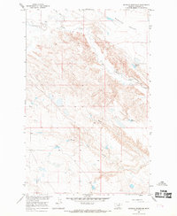
1965 Map of Seymour Reservoir
USGS Topo · Published 1969About this map
Rudolph Valley defines the northern reaches of this mid-1960s landscape, where the drainage patterns of the Missouri River Basin shape the local geography. The area is marked by a network of intermittent waterways and coulees, including the North Fork White Rock Coulee and Big Warm Creek. Human modification of the arid terrain is evident in the presence of water management features such as Seymour Reservoir and Bass Reservoir, which served as critical infrastructure for ranching and settlement in Phillips County. The small settlement of Rankin stands as a primary point of interest for local historians, situated amidst a complex topography of ridges and drainages like Wild Horse Creek. This survey provides a precise record of the land use and water resources in this portion of Montana during the mid-twentieth century.
Find a feature on this map
7 named features on this map. Tap any name to fly to it.
Don’t see what you’re looking for? This feature index may not catch every label — zoom into the map to look around manually.
Map Details
Editions of this 1965 Seymour Reservoir Map
This is the sole edition of this map. No revisions or reprints were ever made.
Other maps of this area

1953 · Havre
USGS Topo · 1:250,000

1954 · Jordan
USGS Topo · 1:250,000

1954 · Glasgow
USGS Topo · 1:250,000

1954 · Lewistown
USGS Topo · 1:250,000

1956 · Jordan
USGS Topo · 1:250,000

1957 · Glasgow
USGS Topo · 1:250,000

1957 · Havre
USGS Topo · 1:250,000

1958 · Glasgow
USGS Topo · 1:250,000

1958 · Jordan
USGS Topo · 1:250,000

1958 · Havre
USGS Topo · 1:250,000