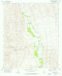
1973 Map of Wildhorse Mtn.
USGS Topo · Published 1976About this map
The San Pedro River flows through the center of this 1970s landscape, carving out the San Pedro Valley between significant mountain ranges. To the west, the Rincon Mountains and Little Rincon Mountains dominate the topography, punctuated by the namesake Wildhorse Mtn. The valley floor is characterized by an extensive network of water resources, including dozens of mapped wells and landmarks like Diamond Spring and Palomas Spring. A notable human element in this arid environment is the Apodaca Cem, located near the riverbanks. The terrain is marked by numerous drainage features such as Kelsey Canyon, Palomas Wash, and Redrock Creek, all feeding toward the river corridor. A Gaging Station at The Narrows indicates the importance of water monitoring in this high-desert watershed during the early 1970s.
Find a feature on this map
30 named features on this map. Tap any name to fly to it.
Don’t see what you’re looking for? This feature index may not catch every label — zoom into the map to look around manually.
Map Details
Editions of this 1973 Wildhorse Mtn. Map
2 editions found
Other maps of this area

1943 · Dragoon
USGS Topo · 1:62,500

1943 · Winchester Mts.
USGS Topo · 1:62,500

1945 · Redington
USGS Topo · 1:62,500

1945 · Winchester Mts.
USGS Topo · 1:62,500

1945 · Happy Valley
USGS Topo · 1:62,500

1956 · Tucson
USGS Topo · 1:250,000

1957 · Redington
USGS Topo · 1:62,500

1957 · Winchester Mts.
USGS Topo · 1:62,500

1958 · Tucson
USGS Topo · 1:250,000

1958 · Happy Valley
USGS Topo · 1:62,500