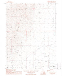
1987 Map of Wildhorse Spring
USGS Topo · Published 1988About this map
West Humboldt Range topography dominates this 1980s landscape, revealing a high-desert environment defined by mining exploration and ephemeral water sources. The western slopes are dotted with numerous Prospect sites and a prominent Open Pit Mine, indicating the intense geological interest in these mountains during the late 20th century. Toward the southeast, the terrain descends sharply into the Carson Sink, where the environment transitions to Sand Dunes and the broad, arid expanse of a Dry Lake. This survey captures the precarious balance of the Great Basin, where named reliable water such as Wildhorse Spring served as vital landmarks for those traversing the rugged gap between the peaks and the sink. The presence of the Packard Wash and various Prospects suggests a landscape shaped by both seasonal runoff and the persistent search for mineral wealth along the Pershing and Churchill county line.
Find a feature on this map
11 named features on this map. Tap any name to fly to it.
Don’t see what you’re looking for? This feature index may not catch every label — zoom into the map to look around manually.
Map Details
Editions of this 1987 Wildhorse Spring Map
This is the sole edition of this map. No revisions or reprints were ever made.
Other maps of this area

1908 · Carson Sink
USGS Topo · 1:250,000

1910 · Carson Sink
USGS Topo · 1:250,000

1931 · Lovelock
USGS Topo · 1:250,000

1935 · Lovelock
USGS Topo · 1:250,000

1954 · Buffalo Mtn
USGS Topo · 1:62,500

1955 · Lovelock
USGS Topo · 1:250,000

1956 · Lovelock
USGS Topo · 1:62,500

1957 · Reno
USGS Topo · 1:250,000

1959 · Lovelock
USGS Topo · 1:250,000

1959 · Reno
USGS Topo · 1:250,000