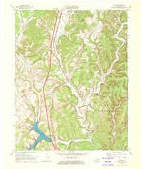
1970 Map of Wildie
USGS Topo · Published 1972About this map
Lake Linville and the entertainment hub of Renfro Valley anchor the southern reaches of this 1970 landscape, where the Louisville and Nashville railroad winds through the valleys of the Daniel Boone National Forest. The map documents a rural transition as modern infrastructure, including a Radio Tower (WVRK) and a Drive-in Theater, appears alongside deep-rooted community landmarks like Brindle Ridge Ch and Union Chapel. Small family settlements and rail-side stops like Wildie, Roundstone, and Conway are mapped in detail, showing their proximity to the rugged Brindle Ridge and Lear Knob. Genealogists will find significant value in the documentation of several family burial sites, including the Himes Cem, Saylor Cem, and Riddle Cem, preserved here before late-century development altered the local topography.
Find a feature on this map
48 named features on this map. Tap any name to fly to it.
Don’t see what you’re looking for? This feature index may not catch every label — zoom into the map to look around manually.
Map Details
Editions of this 1970 Wildie Map
This is the sole edition of this map. No revisions or reprints were ever made.
Other maps of this area

1892 · Richmond
USGS Topo · 1:125,000

1893 · London
USGS Topo · 1:125,000

1897 · Richmond
USGS Topo · 1:125,000

1897 · London
USGS Topo · 1:125,000

1952 · Berea
USGS Topo · 1:24,000

1952 · Paint Lick
USGS Topo · 1:24,000

1952 · Bighill
USGS Topo · 1:24,000

1953 · Johnetta
USGS Topo · 1:24,000

1953 · Maretburg
USGS Topo · 1:24,000

1953 · Wildie
USGS Topo · 1:24,000