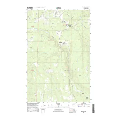
2017 Map of Wilkeson
USGS Topo · Published 2017About this map
Carbonado and Wilkeson anchor this study of the Carbon River corridor, where the legacy of Pierce County's industrial past meets the borders of Mount Rainier National Park. The landscape is defined by the steep descents toward the Carbon River and its various tributaries, such as Wilkeson Cr and Voight Cr. This era of the region’s development is visible in the network of local roads and surviving settlement patterns, including the locations of Fairfax and Upper Fairfax near the river’s edge. Notable infrastructure like the Fairfax Bridge and names like Burnit Coalmine Rd reflect the historical importance of resource extraction and transit in the Carbon River valley. To the east, the terrain rises toward Gleason Hill and Wingate Hill, while recreational spots like Sunset Lake and Kepka Fishing Pond provide a contrast to the industrial character of the valley floor.
Find a feature on this map
77 named features on this map. Tap any name to fly to it.
Don’t see what you’re looking for? This feature index may not catch every label — zoom into the map to look around manually.
Map Details
Editions of this 2017 Wilkeson Map
This is the sole edition of this map. No revisions or reprints were ever made.
Other maps of this area

1897 · Tacoma
USGS Topo · 1:125,000

1900 · Tacoma
USGS Topo · 1:125,000

1913 · Cedar Lake
USGS Topo · 1:125,000

1924 · Mt Rainier
USGS Topo · 1:96,000

1928 · Mt Rainier
USGS Topo · 1:125,000

1937 · Eatonville
USGS Topo · 1:125,000

1942 · Lake Tapps
USGS Topo · 1:62,500

1944 · Lake Tapps
USGS Topo · 1:62,500

1950 · Yakima
USGS Topo · 1:250,000

1953 · Hoquiam
USGS Topo · 1:250,000