1948 Map of Williams
USGS Topo · Published 1951About this map
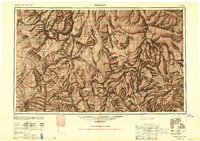
Hualpai Indian Reservation and the sprawling Kaibab National Forest dominate this mid-century western landscape, illustrating the intricate relationship between federal land management and transport corridors. The Atchison Topeka and Santa Fe railroad serves as the primary backbone through the territory, passing through vital hubs like Ashfork and Williams. To the west, mining history is evident at the Music Mountain Mine and Hackberry Mine, while the southern reaches show the early infrastructure of the Prescott National Forest. Significant water features like Laguna Lake and Bishops Lake are mapped alongside the Grand Canyon National Park boundary in the northeast. This era reflects a period of established ranching and forestry, supported by a network of ranger stations such as the Anita Ranger Station and Moqui Camp.
Find a feature on this map
115 named features on this map. Tap any name to fly to it.
Don’t see what you’re looking for? This feature index may not catch every label — zoom into the map to look around manually.
Map Details
Editions of this 1948 Williams Map
2 editions found

Other maps of this area

1886 · Diamond Creek
USGS Topo · 1:250,000

1886 · Camp Mohave
USGS Topo · 1:250,000

1886 · Saint Thomas
USGS Topo · 1:250,000

1886 · San Francisco Mtns
USGS Topo · 1:250,000

1886 · Mt. Trumbull
USGS Topo · 1:250,000

1886 · Chino
USGS Topo · 1:250,000

1886 · Echo Cliffs
USGS Topo · 1:250,000

1886 · Kaibab
USGS Topo · 1:250,000

1887 · Verde
USGS Topo · 1:250,000

1887 · Prescott
USGS Topo · 1:250,000