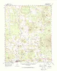
1960 Map of Williams
USGS Topo · Published 1970About this map
Williams serves as the focal point for this high-altitude landscape in the Kaibab National Forest, where the high desert meets the ponderosa pine forests of northern Arizona. The infrastructure of the mid-twentieth century is clearly defined by the Atchison Topeka and Santa Fe railroad and a network of pipelines that traverse the volcanic terrain. Water management is a central theme, evidenced by numerous tanks and reservoirs like Kaibab Lake, Red Lake, and Davenport Lake, which provided essential resources for both ranching and the growing community. Further north, the Grand Canyon Trading Post stands near Howard Mesa, marking the transit corridor toward the canyon. The map also reveals the area's industrial activity through scattered Cinder Pits and the presence of the Airport and its associated Beacon, reflecting the importance of aerial and rail navigation in this geographically significant region.
Find a feature on this map
78 named features on this map. Tap any name to fly to it.
Don’t see what you’re looking for? This feature index may not catch every label — zoom into the map to look around manually.
Map Details
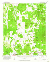
Editions of this 1960 Williams Map
2 editions found
Other maps of this area

1886 · San Francisco Mtns
USGS Topo · 1:250,000

1886 · Chino
USGS Topo · 1:250,000

1891 · San Francisco Mtns
USGS Topo · 1:250,000

1891 · Chino
USGS Topo · 1:250,000

1894 · San Francisco Mtns
USGS Topo · 1:250,000

1899 · San Francisco Mtns
USGS Topo · 1:250,000

1908 · Flagstaff
USGS Topo · 1:125,000

1912 · Flagstaff
USGS Topo · 1:125,000

1922 · Williams
USGS Topo · 1:125,000

1947 · Flagstaff
USGS Topo · 1:250,000