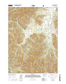
2014 Map of Williams
USGS Topo · Published 2014About this map
The settlement of Williams sits at the heart of this Josephine County survey, serving as a hub for the agricultural and timbered lands along Williams Cr and its many tributaries. The landscape is defined by its water management, evidenced by the numerous small impoundments such as Hartley Reservoir, Dunlap Reservoir, and Miller Reservoir that support the valley. To the south, the terrain rises into the protected reaches of the Siskiyou National Forest and Rogue River National Forest, where features like Little Sugarloaf Peak and Grayback Glades overlook the Low Divide. Genealogists will find notable value in the location of several family and community burial sites, including Gotcher Cem, Spartin Cem, and Hartley Cem, which are scattered among the gulches and flats of this southern Oregon community.
Find a feature on this map
108 named features on this map. Tap any name to fly to it.
Don’t see what you’re looking for? This feature index may not catch every label — zoom into the map to look around manually.
Map Details
Editions of this 2014 Williams Map
This is the sole edition of this map. No revisions or reprints were ever made.
Other maps of this area

1908 · Grants Pass
USGS Topo · 1:125,000

1954 · Oregon Caves
USGS Topo · 1:62,500

1954 · Gold Hill
USGS Topo · 1:62,500

1954 · Grants Pass
USGS Topo · 1:62,500

1954 · Ruch
USGS Topo · 1:62,500

1955 · Medford
USGS Topo · 1:250,000

1957 · Medford
USGS Topo · 1:250,000

1958 · Medford
USGS Topo · 1:250,000
1983 · Tallowbox Mtn
USGS Topo · 1:24,000
1983 · Carberry Creek
USGS Topo · 1:24,000