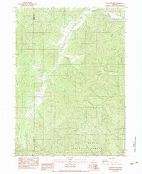
1983 Map of Tallowbox Mtn
USGS Topo · Published 1983About this map
Tallowbox Mountain and the high ridges of the Rogue River National Forest dominate this 1980s landscape on the border of Josephine and Jackson Counties. The terrain is defined by a dense network of gulches and creeks, including the south-flowing Thompson Creek and the Applegate River cutting across the northern edge. This area reflects a long-standing history of mineral exploration, marked by distinctively named sites such as the Bone of Contention Mine, Layton Mine, and Maid of the Mist Mine. The distribution of these claims, along with the Star Mine, suggests a landscape heavily shaped by prospectors working the steep drainages. High points like Jim Mee Peak and Nine Mile Peak overlook a system of forked waters and natural landmarks like Mee Jamison Cove Creek and Ruch Pond, illustrating the complex topography that historically challenged travel and extraction in this corner of Oregon.
Find a feature on this map
43 named features on this map. Tap any name to fly to it.
Don’t see what you’re looking for? This feature index may not catch every label — zoom into the map to look around manually.
Map Details
Editions of this 1983 Tallowbox Mtn Map
This is the sole edition of this map. No revisions or reprints were ever made.
Other maps of this area

1908 · Grants Pass
USGS Topo · 1:125,000

1954 · Oregon Caves
USGS Topo · 1:62,500

1954 · Gold Hill
USGS Topo · 1:62,500

1954 · Grants Pass
USGS Topo · 1:62,500

1954 · Ruch
USGS Topo · 1:62,500

1955 · Medford
USGS Topo · 1:250,000

1957 · Medford
USGS Topo · 1:250,000

1958 · Medford
USGS Topo · 1:250,000
1983 · Mt. Isabelle
USGS Topo · 1:24,000
1983 · Squaw Lakes
USGS Topo · 1:24,000