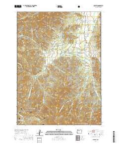
2020 Map of Williams
USGS Topo · Published 2020About this map
The community of Williams sits at the heart of this Josephine County terrain, where the valley floor meets the northern edges of the Siskiyou National Forest and Rogue River National Forest. A complex network of drainage basins and irrigation sources defines the local geography, visible in the numerous private water storage sites such as Kings Reservoir, Remey Reservoir, and Trader Reservoir. These water features support a landscape carved by distinct gulches including Maple Springs Gulch and Bamboo Gulch.
Find a feature on this map
87 named features on this map. Tap any name to fly to it.
Don’t see what you’re looking for? This feature index may not catch every label — zoom into the map to look around manually.
Map Details
Editions of this 2020 Williams Map
This is the sole edition of this map. No revisions or reprints were ever made.
Other maps of this area

1908 · Grants Pass
USGS Topo · 1:125,000

1954 · Oregon Caves
USGS Topo · 1:62,500

1954 · Gold Hill
USGS Topo · 1:62,500

1954 · Grants Pass
USGS Topo · 1:62,500

1954 · Ruch
USGS Topo · 1:62,500

1955 · Medford
USGS Topo · 1:250,000

1957 · Medford
USGS Topo · 1:250,000

1958 · Medford
USGS Topo · 1:250,000
1983 · Tallowbox Mtn
USGS Topo · 1:24,000
1983 · Carberry Creek
USGS Topo · 1:24,000