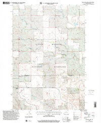
1997 Map of Williams Lake
USGS Topo · Published 2001About this map
The Little Missouri National Grassland dominates this portion of the Badlands, where the drainage systems of Bull Run and Cottonwood Creek carve into the high plains. This landscape is defined by its water management and grazing history, evidenced by the Horse Creek Association Headquarters and the isolated Northrup Ranch. The survey captures a ranching economy reliant on the scattered network of wells and unique water features like the Flowing Well and Williams Lake. Situated along the boundary of Golden Valley and Slope counties, the map illustrates the transition from high plateau to the intricate creek beds of Horse Creek and Deer Creek, providing a detailed view of North Dakota's western rangeland as it was managed in the late 1990s.
Find a feature on this map
14 named features on this map. Tap any name to fly to it.
Don’t see what you’re looking for? This feature index may not catch every label — zoom into the map to look around manually.
Map Details
Editions of this 1997 Williams Lake Map
This is the sole edition of this map. No revisions or reprints were ever made.
Other maps of this area

1953 · Miles City
USGS Topo · 1:250,000

1953 · Dickinson
USGS Topo · 1:250,000

1957 · Dickinson
USGS Topo · 1:250,000

1957 · Miles City
USGS Topo · 1:250,000

1958 · Miles City
USGS Topo · 1:250,000

1979 · Three V Crossing
USGS Topo · 1:24,000

1980 · Golva
USGS Topo · 1:24,000

1980 · Pretty Butte
USGS Topo · 1:24,000

1980 · Boyce Creek West
USGS Topo · 1:24,000

1980 · Alpha
USGS Topo · 1:24,000