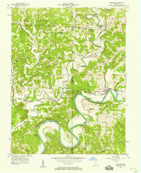
1957 Map of Williams
USGS Topo · Published 1969About this map
The East Fork White River dominates this mid-century landscape, carving deep, dramatic meanders like Henshaw Bend through Lawrence and Martin counties. This 1957 survey captures the intersection of heavy military presence and rural southern Indiana life, with the southern boundary of the U S Naval Reservation Crane Ammunition Depot bordering small agrarian communities and the sprawling Hoosier National Forest. The village of Williams serves as a local hub near the Williams Bridge, situated along the winding route of the Chicago Milwaukee St Paul and Pacific railroad.
Find a feature on this map
33 named features on this map. Tap any name to fly to it.
Don’t see what you’re looking for? This feature index may not catch every label — zoom into the map to look around manually.
Map Details
Editions of this 1957 Williams Map
2 editions found
Other maps of this area

1935 · Oolitic
USGS Topo · 1:48,000

1942 · Oolitic
USGS Topo · 1:62,500

1948 · Huron
USGS Topo · 1:24,000

1949 · Georgia
USGS Topo · 1:24,000

1950 · Huron
USGS Topo · 1:24,000

1950 · Shoals
USGS Topo · 1:24,000

1951 · Georgia
USGS Topo · 1:24,000

1956 · Koleen
USGS Topo · 1:24,000

1956 · Indian Springs
USGS Topo · 1:24,000

1956 · Vincennes
USGS Topo · 1:250,000