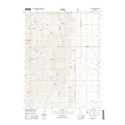
2014 Map of Williams Peak
USGS Topo · Published 2014About this map
Fishlake National Forest dominates this high-altitude landscape in the Canyon Mountains along the border of Millard and Juab counties. The terrain is defined by a dense network of drainages and peaks, including the prominent Williams Peak and the protected Partridge Mountain Research Natural Area. Deeply etched canyons like John Williams Canyon, Rattlesnake Canyon, and Devil Canyon suggest a rugged geography that has historically challenged settlement and directed movement along the few established routes. To the southeast, the land descends into the Scipio Valley, where the transition from steep slopes to broader basins becomes apparent. While water is scarce, isolated sources such as Fishers Spring and Quarry Spring indicate the critical points that sustained livestock and wildlife in this high-country environment. The road network remains sparse, consisting primarily of tracks like Dry Creek Rd and Oak Creek Canyon Rd that provide access to the interior for forest management and recreation.
Find a feature on this map
48 named features on this map. Tap any name to fly to it.
Don’t see what you’re looking for? This feature index may not catch every label — zoom into the map to look around manually.
Map Details
Editions of this 2014 Williams Peak Map
This is the sole edition of this map. No revisions or reprints were ever made.
Other maps of this area

1885 · Sevier Desert
USGS Topo · 1:250,000

1951 · Oak City
USGS Topo · 1:62,500

1952 · Scipio North
USGS Topo · 1:62,500

1953 · Delta
USGS Topo · 1:250,000

1958 · Delta
USGS Topo · 1:250,000

1962 · Delta
USGS Topo · 1:250,000

1962 · Holden
USGS Topo · 1:62,500
1969 · Scipio Pass
USGS Topo · 1:24,000
1969 · Scipio South
USGS Topo · 1:24,000
1985 · Oak City North
USGS Topo · 1:24,000