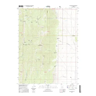
2017 Map of Williams Peak
USGS Topo · Published 2017About this map
Williams Peak rises as the central landmark within this portion of the Fishlake National Forest, where the high elevations of the Canyon Mountains overlook the eastern expanse of Scipio Valley. The landscape is a network of named drainages and hollows, including Eightmile Canyon, Rattlesnake Canyon, and the deep Devil Canyon to the southwest. Human presence in this high-desert terrain is marked by a series of forest routes and family-named landmarks like John Williams Canyon and Yance Canyon. A clear boundary between Juab and Millard Counties cuts across the northern ridges, while essential water sources like Mud Springs and Fishers Spring are tucked away in the lower slopes near the Scipio Pump Station Rd. The drainage patterns, including Little Oak Creek and the W Fork Eight-Mile Cr, define the movement through this high country at the edge of the valley floor.
Find a feature on this map
57 named features on this map. Tap any name to fly to it.
Don’t see what you’re looking for? This feature index may not catch every label — zoom into the map to look around manually.
Map Details
Editions of this 2017 Williams Peak Map
This is the sole edition of this map. No revisions or reprints were ever made.
Other maps of this area

1885 · Sevier Desert
USGS Topo · 1:250,000

1951 · Oak City
USGS Topo · 1:62,500

1952 · Scipio North
USGS Topo · 1:62,500

1953 · Delta
USGS Topo · 1:250,000

1958 · Delta
USGS Topo · 1:250,000

1962 · Delta
USGS Topo · 1:250,000

1962 · Holden
USGS Topo · 1:62,500
1969 · Scipio Pass
USGS Topo · 1:24,000
1969 · Scipio South
USGS Topo · 1:24,000
1985 · Oak City North
USGS Topo · 1:24,000