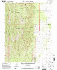
2001 Map of Williams Peak
USGS Topo · Published 2003About this map
Fishlake National Forest dominates this section of the Mountains along the border of Millard and Juab Counties. The terrain is defined by a dense network of drainages including Eightmile Creek, Dry Creek, and Little Oak Creek, which flow through steep corridors like Hardscrabble Canyon and Rogers Canyon. High-altitude landmarks such as Williams Peak and the ridges of Partridge Mountain overlook several springs and remote facilities, including a Gaging Station and the Little Creek Campground.
Find a feature on this map
45 named features on this map. Tap any name to fly to it.
Don’t see what you’re looking for? This feature index may not catch every label — zoom into the map to look around manually.
Map Details
Editions of this 2001 Williams Peak Map
This is the sole edition of this map. No revisions or reprints were ever made.
Other maps of this area

1885 · Sevier Desert
USGS Topo · 1:250,000

1951 · Oak City
USGS Topo · 1:62,500

1952 · Scipio North
USGS Topo · 1:62,500

1953 · Delta
USGS Topo · 1:250,000

1958 · Delta
USGS Topo · 1:250,000

1962 · Delta
USGS Topo · 1:250,000

1962 · Holden
USGS Topo · 1:62,500
1969 · Scipio Pass
USGS Topo · 1:24,000
1969 · Scipio South
USGS Topo · 1:24,000
1985 · Oak City North
USGS Topo · 1:24,000