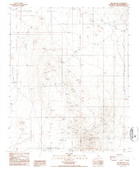
1986 Map of Williams Well
USGS Topo · Published 1986About this map
Superior Valley dominates this high desert landscape, characterized by a complex network of seasonal drainages and mining activity in the mid-1980s. The area around Goldstone is marked by numerous Prospects and a primary Mine, indicating a period of intensive exploration and geological sampling. Transportation is defined by a sparse grid of 4wd tracks and the inclusion of a Landing Strip near the namesake Williams Well, a vital water point in this arid terrain. The presence of the San Bernardino Meridian provides a primary surveying reference point, cutting north-south through the center of the sheet. This map captures a specific moment in the Mojave Desert's history when the landscape was primarily utilized for technical surveying, remote aviation, and mineral prospecting, balanced against the natural features of the dry Wash beds that crisscross the valley floor.
Find a feature on this map
12 named features on this map. Tap any name to fly to it.
Don’t see what you’re looking for? This feature index may not catch every label — zoom into the map to look around manually.
Map Details
Editions of this 1986 Williams Well Map
This is the sole edition of this map. No revisions or reprints were ever made.
Other maps of this area

1915 · Searles Lake
USGS Topo · 1:250,000

1933 · Avawatz Mountains
USGS Topo · 1:250,000

1947 · Trona
USGS Topo · 1:250,000

1948 · Trona
USGS Topo · 1:250,000

1948 · Lane Mountain
USGS Topo · 1:62,500

1948 · Goldstone Lake
USGS Topo · 1:62,500

1951 · Goldstone Lake
USGS Topo · 1:62,500

1951 · Lane Mountain
USGS Topo · 1:62,500

1953 · Trona
USGS Topo · 1:250,000

1954 · Pilot Knob
USGS Topo · 1:62,500