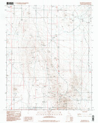
1996 Map of Williams Well
USGS Topo · Published 1998About this map
Superior Valley dominates this high-desert landscape in San Bernardino County, as seen in the mid-1990s. The area is defined by a sparse but active network of 4wd trails and extraction-related activity, centered around the Williams Well settlement and the Goldstone site. Numerous Prospects and a primary Mine are scattered across the terrain, indicating a history of mineral exploration that persists alongside aviation infrastructure like the Landing Strip near the southern boundary. The San Bernardino Meridian bisects the quadrangle, serving as a critical reference point for the grid of section lines that organize this arid expanse. This survey reflects the intersection of traditional desert resource extraction and modern specialized uses within the vast interior basins.
Find a feature on this map
12 named features on this map. Tap any name to fly to it.
Don’t see what you’re looking for? This feature index may not catch every label — zoom into the map to look around manually.
Map Details
Editions of this 1996 Williams Well Map
This is the sole edition of this map. No revisions or reprints were ever made.
Other maps of this area

1915 · Searles Lake
USGS Topo · 1:250,000

1933 · Avawatz Mountains
USGS Topo · 1:250,000

1947 · Trona
USGS Topo · 1:250,000

1948 · Trona
USGS Topo · 1:250,000

1948 · Lane Mountain
USGS Topo · 1:62,500

1948 · Goldstone Lake
USGS Topo · 1:62,500

1951 · Goldstone Lake
USGS Topo · 1:62,500

1951 · Lane Mountain
USGS Topo · 1:62,500

1953 · Trona
USGS Topo · 1:250,000

1954 · Pilot Knob
USGS Topo · 1:62,500