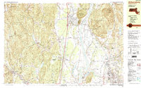
1990 Map of Williamsburg
USGS Topo · Published 1990About this map
The Connecticut River meanders through this portion of the valley, separating the peaks of Mt Toby State Forest from the agricultural and academic centers of the west. In the late twentieth century, the landscape shows a mix of dense forest reservations and established settlements like South Deerfield and Williamsburg. The southern portion is dominated by the sprawling campus of the University of Massachusetts, featuring prominent landmarks such as Alumni Stadium and a Powerplant. Genealogists may find interest in several cemeteries, including Holy Ghost Cem and Stanislaus Cem, which reflect the area's cultural history. Natural resource management is evident through the State Fish Hatchery and several water bodies like Lake Warner and the Northampton Reservoir. The presence of an Old RR Grade hints at the changing transportation networks that once linked these valley towns.
Find a feature on this map
142 named features on this map. Tap any name to fly to it.
Don’t see what you’re looking for? This feature index may not catch every label — zoom into the map to look around manually.
Map Details
Editions of this 1990 Williamsburg Map
2 editions found
Other maps of this area

1885 · Northampton
USGS Topo · 1:62,500

1886 · Hawley
USGS Topo · 1:62,500

1886 · Chesterfield
USGS Topo · 1:62,500

1886 · Northampton
USGS Topo · 1:62,500

1887 · Warwick
USGS Topo · 1:62,500

1887 · Belchertown
USGS Topo · 1:62,500

1888 · Chesterfield
USGS Topo · 1:62,500

1889 · Warwick
USGS Topo · 1:62,500

1890 · Hawley
USGS Topo · 1:62,500

1890 · Belchertown
USGS Topo · 1:62,500