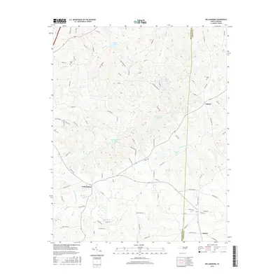
2016 Map of Williamsburg
USGS Topo · Published 2016About this map
The Haw River winds through the southern landscape of this Rockingham and Caswell County borderland, anchored by the community of Williamsburg. This 2016 survey illustrates a terrain defined by its water resources, from the expansive Rockingham Lake and Williamsburg Wildlife Lake to smaller catchments like Lake Wade and Beaver Lodge Lake Number One. The map provides a detailed view of the rural road network, showing how routes like Ashland Rd and Tate Rd connect the settlements of Ashland and Matkins. For those tracing local families, the presence of Settle Cem and Apple Cem offers specific points of genealogical interest. The drainage patterns of Hogans Cr and Country Line Cr further dictate the character of these North Carolina uplands, where small-scale agriculture and managed water bodies dominate the landscape.
Find a feature on this map
89 named features on this map. Tap any name to fly to it.
Don’t see what you’re looking for? This feature index may not catch every label — zoom into the map to look around manually.
Map Details
Editions of this 2016 Williamsburg Map
This is the sole edition of this map. No revisions or reprints were ever made.
Other maps of this area

1951 · Browns Summit
USGS Topo · 1:24,000

1953 · Greensboro
USGS Topo · 1:250,000

1954 · Greensboro
USGS Topo · 1:250,000

1962 · Greensboro
USGS Topo · 1:250,000

1966 · Greensboro
USGS Topo · 1:250,000

1969 · Lake Burlington
USGS Topo · 1:24,000

1970 · Ossipee
USGS Topo · 1:24,000
1971 · Southeast Eden
USGS Topo · 1:24,000
1971 · Ruffin
USGS Topo · 1:24,000
1972 · Williamsburg
USGS Topo · 1:24,000