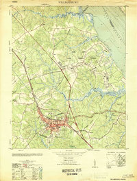
1951 Map of Williamsburg
USGS Topo · Published 1951About this map
The colonial capital and its 20th-century military surroundings come into focus in this mid-century survey of Williamsburg, Virginia. While the historic core is defined by landmarks like the Governors Palace, the Capitol, and the sprawling campus of William and Mary College, the periphery reveals the area's massive expansion during the war years. To the north, the Camp Peary Naval Training Station occupies a vast tract along the York River, having displaced earlier rural life near Magruder and Skimino.
Find a feature on this map
46 named features on this map. Tap any name to fly to it.
Don’t see what you’re looking for? This feature index may not catch every label — zoom into the map to look around manually.
Map Details
Editions of this 1951 Williamsburg Map
This is the sole edition of this map. No revisions or reprints were ever made.
Other maps of this area

1906 · Williamsburg
USGS Topo · 1:62,500

1907 · Yorktown
USGS Topo · 1:62,500

1917 · Toano
USGS Topo · 1:62,500

1918 · Toano
USGS Topo · 1:62,500

1919 · Surry
USGS Topo · 1:62,500

1943 · Yorktown
USGS Topo · 1:62,500

1943 · Richmond
USGS Topo · 1:250,000

1944 · Yorktown
USGS Topo · 1:24,000

1949 · Richmond
USGS Topo · 1:250,000

1950 · Cobham Bay
USGS Topo · 1:24,000