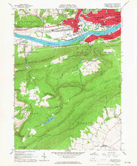
1965 Map of Williamsport
USGS Topo · Published 1967About this map
Williamsport sits as a regional hub on the northern bank of the West Branch Susquehanna River, where it meets the waters of Lycoming Creek. In the mid-1960s, the city is a dense grid of industry and education, featuring the Williamsport Area Community College and a complex rail network serviced by the Pennsylvania RR and Reading RR. Local neighborhoods like Newberry and Glosser View extend westward, while the southern bank hosts Duboistown and South Williamsport at the foot of the mountain.
Find a feature on this map
70 named features on this map. Tap any name to fly to it.
Don’t see what you’re looking for? This feature index may not catch every label — zoom into the map to look around manually.
Map Details
Editions of this 1965 Williamsport Map
4 editions found
Other maps of this area

1921 · Williamsport
USGS Topo · 1:48,000

1921 · Trout Run
USGS Topo · 1:62,500

1923 · Trout Run
USGS Topo · 1:62,500

1923 · Williamsport
USGS Topo · 1:62,500

1924 · Milton
USGS Topo · 1:62,500

1930 · Warrensville
USGS Topo · 1:62,500

1934 · Warrensville
USGS Topo · 1:62,500

1944 · Trout Run
USGS Topo · 1:62,500

1944 · Williamsport
USGS Topo · 1:62,500

1953 · Warrensville
USGS Topo · 1:62,500
Featured Places
- Williamsport, PA
- Garden View, Old Lycoming Township
- Duboistown, PA
- Bastress Township, PA
- Woodward Township, PA