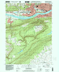
1994 Map of Williamsport
USGS Topo · Published 1999About this map
Williamsport serves as the industrial and civic heart of this mid-1990s survey, where the West Branch Susquehanna River separates the dense urban grid from the steep slopes of Bald Eagle Mountain. The city's northern neighborhoods, including Newberry and Grimesville, are defined by a concentration of educational and spiritual landmarks such as the Andrew Jackson Sch and Wildwood Cemetery. South of the river, South Williamsport and Duboistown give way to the forested expanse of State Game Lands No 126 and the Tiadaghton North State Forest.
Find a feature on this map
51 named features on this map. Tap any name to fly to it.
Don’t see what you’re looking for? This feature index may not catch every label — zoom into the map to look around manually.
Map Details
Editions of this 1994 Williamsport Map
This is the sole edition of this map. No revisions or reprints were ever made.
Other maps of this area

1921 · Williamsport
USGS Topo · 1:48,000

1921 · Trout Run
USGS Topo · 1:62,500

1923 · Trout Run
USGS Topo · 1:62,500

1923 · Williamsport
USGS Topo · 1:62,500

1924 · Milton
USGS Topo · 1:62,500

1930 · Warrensville
USGS Topo · 1:62,500

1934 · Warrensville
USGS Topo · 1:62,500

1944 · Trout Run
USGS Topo · 1:62,500

1944 · Williamsport
USGS Topo · 1:62,500

1953 · Warrensville
USGS Topo · 1:62,500
Featured Places
- Williamsport, PA
- Garden View, Old Lycoming Township
- Duboistown, PA
- Bastress Township, PA
- Woodward Township, PA