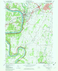
1979 Map of Williamsport
USGS Topo · Published 1979About this map
The Potomac River carves a deep, winding path through this Maryland and West Virginia borderlands map, framing a landscape defined by industrial development and historical preservation. The Chesapeake and Ohio Canal National Historical Park traces the northern bank, marking a transition from the historic river-borne transport era to the late-20th-century prominence of Conrail and Norfolk and Western rail lines. In Williamsport, the confluence of the Conococheague Creek with the Potomac reveals a dense infrastructure of a Power Plant, Sewage Disposal, and Industrial Waste Ponds reflecting the region's mid-century utility footprint. Eastward, the settlement of Halfway shows significant residential growth near the Bnai Abraham Cem, while smaller rural pockets like Downsville, Grimes, and Bakersville maintain their character through local landmarks like Downsville Ch and the Salem Ch. The peninsula at Whitings Neck highlights the dramatic river bends that dictate the local geography.
Find a feature on this map
74 named features on this map. Tap any name to fly to it.
Don’t see what you’re looking for? This feature index may not catch every label — zoom into the map to look around manually.
Map Details
Editions of this 1979 Williamsport Map
This is the sole edition of this map. No revisions or reprints were ever made.
Other maps of this area

1884 · Harpers Ferry
USGS Topo · 1:125,000

1891 · Harpers Ferry
USGS Topo · 1:125,000

1893 · Harpers Ferry
USGS Topo · 1:125,000

1908 · Middletown
USGS Topo · 1:48,000

1909 · Hagerstown
USGS Topo · 1:48,000

1910 · Antietam
USGS Topo · 1:62,500

1912 · Hagerstown
USGS Topo · 1:62,500

1912 · Williamsport
USGS Topo · 1:62,500

1914 · Martinsburg
USGS Topo · 1:48,000

1916 · Martinsburg
USGS Topo · 1:62,500